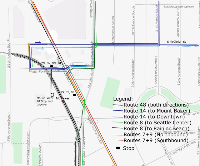
The solutions in this article assume that the Light Rail station will not move anytime soon and are fixes to the bus service and stop locations, and hopefully minor upgrades to the Link station itself and installment of signal priority to minimize delays.
Route 48
Currently, Route 48 has Mount Baker Transit Center as its southern terminus. It is an integral city connector and has very high ridership. To me, the fix is simple for this route. Instead of taking the lengthy tour it makes around the Transit Center before actually stopping, it can simply continue along Rainier Avenue South until it reaches South Forest Street, where it takes a right than a quick left onto the unused 27th Avenue South. This street would be rendered transit-only, and its roundabout at the station, which marks the end of the street, would be both the Transit Center Stop and the layover for the 48.
Route 14
Route 14 goes through Mount Baker Transit Center on both directions of its trips, but because Mount Baker TC is slightly out of the way of its normal path, buses in both directions end up heading to and from the station the same way, meaning that the 14 fix only requires one direction of routing.
The best way to fix this for me is to make the route use the transit center as a shortcut to get onto South Forest Street westbound, merging with the 48 for a short period of time. Instead of using the 48's layover, it would stop where the 48 would turn off onto 27th Ave for a quick connection to the station. It would then continue, following the arterial until McClellan Street, where it would turn right and continue its original route. Not too much more catenary would have to be built.
Routes 7 and 9
I have combined the 7 and 9 because they follow the same route through Mount Baker Transit Center. Similarly to the 14, the northbound routes of the 7 and 9 would take a left onto South Forest Street from Rainier and then follow the same route as the 14 and stopping at the stop on South Forest Street, where the 14, in the above section, would also stop. From there, it would follow the arterial back to McClellan, where it would take a left back onto Rainier, hopefully with some kind of signal priority, especially for the 7X.
The southbound routes would continue using their normal stop adjacent to the light rail system on Rainier Avenue South, the 7X included, which provides a very efficient connection to the station.
Route 8
Route 8 would see similar adjustments. Southbound, Route 8 would use the 14's route along Martin Luther King Jr. Way and use the current transit center as a road, but would turn left onto Rainier Avenue South and stop at the southbound 7 and 9 stops adjacent to the station for a quick connection.
Northbound, the 8 would take a left onto Rainier Avenue South from MLK and would turn left onto South Forest Street, stopping at the northbound 7 and 9 stop and 14 stop just above the station, and then continuing the 14 route until rejoining Martin Luther King Way, where it would take a left to resume its normal route.
Closing Statements
These are just preliminary route and stop relocations. Ideally, signal priority would be used for all routes, especially considering that if such a technology was not put in, delays of multiple minutes would become regular.
A more hopeful proposition is to put in another escalator entrance to both sides of the light rail station on the north of the platform, which would make getting off of the train and accessing it from the new stop on South Forest Street much easier and less lengthy. Currently, there is only one escalator, and it is on the far south side of the platform, which means getting off from the back of the train becomes tedious.
Map
 |
| OpenStreetMap and some questionable editing on my part. |